


Living Information
Read the Tsunami Hazard Map (「あなたの街の津波ハザードマップ」を読もう)
2022.02.27
The City of Nagoya provides Tsunami Hazard Maps for areas of the city which could be at risk of inundation if tsunami were to occur. Although published in Japanese, knowing how to read a few of the captions on the map side will allow you to assess the potential hazard for your home, school or workplace. You can also check the location of Tsunami Evacuation Buildings.
For more on Tsunami Evacuation Buildings, see Be Prepared for Tsunami.
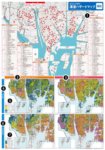
Shown: Minato Ward Tsunami Hazard Map. Layout may differ for other wards
➊ |
津波避難ビル一覧 |
| tsunami hinan biru ichiran | |
| List of Tsunami Evacuation Buildings | |
❷ |
過去の地震を考慮した最大クラス |
| kako no jishin o kōryo shita saidai kurasu | |
| largest class tsunami taking historical earthquake data into account | |
❸ |
あらゆる可能性を考慮した最大クラス |
| arayaru kanōsei o kōryo shita saidai kurasu | |
| largest class tsunami taking all possibilities into account | |
❹ |
浸水範囲 |
| shinsui han'i | |
| extent of inundation | |
❺ |
最大浸水深 |
| saidai shinsui shin | |
| maximum inundation depth | |
以上 |
|
| ijō | |
| over ~; more than ~ | |
未満 |
|
| miman | |
| under ~; less than ~ | |
❻ |
浸水開始時間 |
| shinsui kaishi jikan | |
| time until inundation begins | |
❼ |
浸水開始時間(浸水深30cm) |
| shinsui kaishi jikan (shinsuishin 30cm) | |
| time until inundation begins (inundation depth 30cm) | |
分 |
|
| fun/pun | |
| minutes |