2022.08.30
Earthquake and tsunami hazard maps
From September 2022, the City of Nagoya will introduce new hazard maps for earthquakes and tsunami. The maps are published in Japanese on the City of Nagoya website, but if you can recognize some key expressions, you will be able to get useful information from the map that could save your life and the lives of those around you. Make time to study the hazard maps for your home, school, or workplace, and help yourself to be prepared for when an emergency arises.
Earthquake hazard maps 地震ハザードマップ
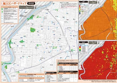
Nakamura Ward earthquake hazard map
The information shown on the new earthquake hazard map is based on damage projections for two potential scenarios for an earthquake originating in the Nankai Trough; specifically, the estimated largest class of earthquake based on both historical data, and a range of other possible factors.
The maps feature estimates of seismic intensity, liquefaction, and designated emergency assembly points (sites where you can initially evacuate from the immediate danger of tremors and fires) and places to obtain water.
Check the earthquake hazard map for your ward on the City of Nagoya website here.
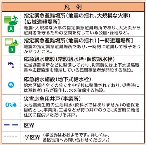
凡例
hanrei (key [to map])
指定緊急避難場所
shitei kinkyū hinan basho (designated emergency assembly points)
・地震の揺れ
jishin no yure (tremors)
・大規模な火事
daikibo na kaji (large-scale fires)
・【広域避難場所】
kōiki hinan basho (wide, open evacuation area [e.g. park])
・【一時避難場所】
ichiji hinan basho (temporary evacuation area)
応急給水施設
ōkyū kyūsui shisetsu (emergency water supply facilities)
災害応急用井戸
saigai ōkyū-yō ido (emergency well for disasters [not drinking water])
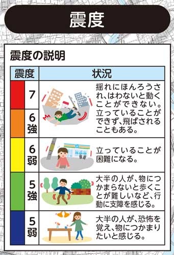
震度
shindo (seismic intensity [Japanese Meteorological Agency scale])
強
[number] kyō ([number]+, e.g. 6+)
弱
[number] jaku ([number]-, e.g. 6-)
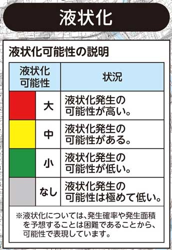
液状化
ekijōka (liquefaction)
液状化可能性
ekijōka kanōsei (possibility of liquefaction occurring)
大
dai (high)
中
chū (medium)
小
shō (low)
なし
nashi (none)
Tsunami hazard maps 津波ハザードマップ
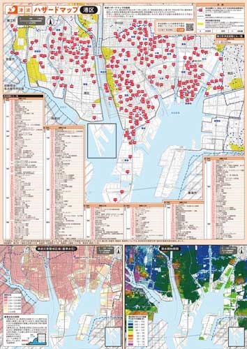
Minato Ward tsunami hazard map
As part of measures towards preventing human casualties, Aichi Prefecture designated areas estimated to be at risk if tsunami of the largest class were to occur as Tsunami Disaster Alert Zones (津波災害警戒区域) in July 2019.
The City of Nagoya's new tsunami hazard map incorporates data for the Tsunami Disaster Alert Zones within Nagoya City, and features estimated extent of inundation and water level, time until inundation, and the location of tsunami evacuation buildings where you can initially evacuate to protect yourself from the immediate danger of tsunami.
Check the tsunami hazard map for your ward on the City of Nagoya website here.

津波避難ビル一覧
tsunami hinan biru ichiran (list of tsunami evacuation buildings)
区
ku (ward)
学区
gakku (school district)
避難ビル名
hinan biru mei ([tsunami] evacuation building name)

津波災害警戒区域
tsunami saigai keikai kuiki (tsunami disaster alert zone)
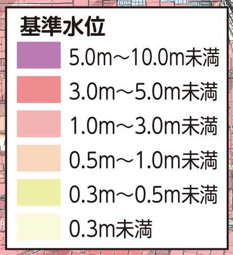
基準水位
kijun suii (water level)
~未満
~miman (less than ~)

浸水開始時間
shinsui kaishi jikan (time until inundation)
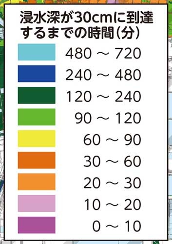
浸水深が30cmに到達するまでの時間
shinsuishin ga 30cm ni tōtatsu suru made no jikan (time until inundation depth reaches 30cm)
(分)
fun/pun (minutes)


