2022.08.30
Storm and flood-related hazard maps
In June 2022, the City of Nagoya introduced new hazard maps for storm and flood-related disasters. These maps feature information on the extent of flooding, flood depth, and how long an area is estimated to remain inundated, along with information on designated emergency assembly points where you can initially evacuate to protect yourself from the immediate danger of the disaster.
The maps are published in Japanese on the City of Nagoya website, but if you can recognize some key expressions, you will be able to get useful information from the map that could save your life and the lives of those around you. Make time to study the hazard maps for your home, school, or workplace, and help yourself to be prepared for when an emergency arises.
Types of storm and flood-related hazard maps
Click on the type of map to open the relevant page on the City of Nagoya website and check the map for your ward.
洪水 kōzui
Flooding, or external inundation, caused by the bursting of a river bank or a river overflowing
内水 naisui
Internal inundation, flooding occurring when drains and sewers cannot cope with a sudden large volume of water from localized heavy rain
高潮 takashio
Storm surge, an extreme rise in sea level as a typhoon approaches that may inundate coastal areas
Look for the following keys and expressions on the maps to help you assess the risk for your area.

浸水の目安
shinsui no meyasu (inundation depth reference)
~階 浸水
[number] kai shinsui (inundation of [number] floor)
以上
~ijō (more than ~; over ~)
未満
~miman (less than ~; under ~)

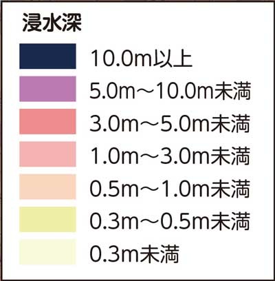
浸水深
shinsuishin (inundation depth)
以上
~ijō (more than ~; over ~)
未満
~miman (less than ~; under ~)

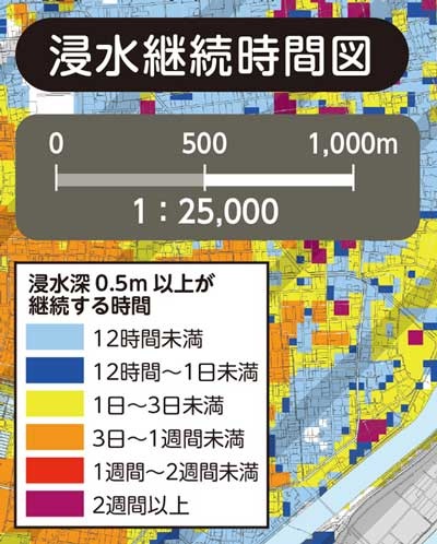
浸水継続時間図
shinsui keizoku jikan zu (chart showing duration of inundation)
浸水深0.5m以上が継続する時間
shinsuishin 0.5m ijō ga keizoku suru jikan (duration of inundation of 0.5m or more)
~時間
~ jikan (~ hour/s)
12時間未満
12 jikan miman (less than 12 hours)
~日
~ nichi / ~ ka (~ day/s)
12時間~1日未満
12 jikan kara ichinichi miman (between 12 hours and 1 day [24 hours])
1日~3日未満
ichinichi kara mikka miman (between 1 day and 3 days)
~週間
~ shūkan (~ week/s)
3日~1週間未満
mikka kara isshūkan miman (between 3 days and 1 week)
1週間~2週間未満
isshūkan kara nishūkan miman (between 1 and 2 weeks)
2週間以上
nishūkan ijō (more than 2 weeks)


